Trail Walking La Chapelle-Janson - À la découverte du Chemin Royal - Photo

À la découverte du Chemin Royal

 JMJ53350
JMJ53350

User

© OpenStreetMap contributors
Length
Length
10.9 km
Max alt
Max alt
243 m
Uphill gradient
Uphill gradient
209 m
Km-Effort
Km-Effort  
13.7 km
Min alt
Min alt
143 m
Downhill gradient
Downhill gradient
213 m
Boucle
Boucle
Yes
Creation date :
2023-03-24 19:44:46.255
Updated on :
2023-03-24 19:45:12.397

(0 Reviews)

Walking
Walking
3h07
Difficulty : Medium

Scan this QR Code to open this trail in the SityTrail application

FREE GPS app for hiking

Logo SityTrail SityTrail

IGN / Geographical institutes

Download SityTrail from the App Store Download SityTrail from Google Play

Logo SityTrail SityTrail World

The world is yours!

Download SityTrail from the App Store Download SityTrail from Google Play Download SityTrail on Huawei AppGallery

About

Trail Walking of 10.9 km to be discovered at Brittany, Ille-et-Vilaine, La Chapelle-Janson. This trail is proposed by JMJ53350.

Elevation profile

Points of interest

Point of interest La Chapelle-Janson - La Pierre, stationnement sur le bas-côté  - Photo
JMJ53350
LA CHAPELLE-JANSON 
Point of interest La Chapelle-Janson - Tout droit à l'aller, à gauche au retour - Photo
JMJ53350
Point of interest La Pellerine - Route à droite - Photo
JMJ53350
LA PELLERINE 
Point of interest La Chapelle-Janson - Chemin à gauche avant la Houdinais - Photo
JMJ53350
Point of interest La Chapelle-Janson - À droite vers le Chemin Royal - Photo
JMJ53350
LA CHAPELLE-JANSON 
Point of interest La Chapelle-Janson - À gauche à l'aller, tout droit au retour - Photo
JMJ53350
Point of interest La Chapelle-Janson - Chemin à droite - Photo
JMJ53350
LA CHAPELLE-JANSON 
Point of interest La Chapelle-Janson - La Pierre, stationnement sur le bas-côté  - Photo
JMJ53350
LA CHAPELLE-JANSON 

Positioning

Country:
France
Region :
Brittany
Department/Province :
Ille-et-Vilaine
Municipality :
La Chapelle-Janson
Location:
Unknown
Start:(UTM)
642909 ; 5357629 (30U) N.

Trails nearby

Trail On foot La Chapelle-Janson - Circuit du Relais des Vallées - Photo
On foot
PRO

On foot

Easy
La Chapelle-Janson, Brittany, Ille-et-Vilaine, France
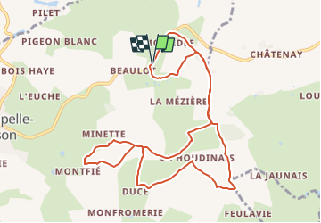
12.8 km | 15.9 km-effort
3h 36min
Yes
Trail Walking La Chapelle-Janson - GR_37_AG_21_Chapelle-Janson_Luitre-Dompierre_20210620 - Photo
Walking
patrickdanilo

Walking

Difficult
La Chapelle-Janson, Brittany, Ille-et-Vilaine, France
13.1 km | 16.2 km-effort
3h 16min
No
Trail Walking La Chapelle-Janson - GR 34 étape 3 - Photo
Walking
lagardienne

Walking

Easy
La Chapelle-Janson, Brittany, Ille-et-Vilaine, France
28 km | 34 km-effort
6h 55min
No
Trail Walking La Chapelle-Janson - Chapelle Janson_Relais des vallées - Photo
Walking
neoroll44

Walking

Medium
La Chapelle-Janson, Brittany, Ille-et-Vilaine, France
12.7 km | 15.8 km-effort
3h 30min
Yes
Trail Walking Fleurigné - Fleurigné - Photo
Walking
neoroll44

Walking

Easy
Fleurigné, Brittany, Ille-et-Vilaine, France
7.3 km | 8.3 km-effort
1h 50min
Yes
Trail Walking Le Loroux - Le Loroux - Photo
Walking
neoroll44

Walking

Easy
Le Loroux, Brittany, Ille-et-Vilaine, France
4.2 km | 5.1 km-effort
1h 10min
Yes
Trail Other activity Fleurigné - gr34anc - Photo
Other activity
leclerc-ray

Other activity

Very easy
Fleurigné, Brittany, Ille-et-Vilaine, France
16.2 km | 19.3 km-effort
Unknown
No
Trail Walking La Chapelle-Janson - La chapelle Janson - Photo
Walking
CANON2

Walking

Easy
La Chapelle-Janson, Brittany, Ille-et-Vilaine, France
11.4 km | 14.3 km-effort
3h 5min
Yes
Trail Walking Fleurigné - bois mary - Photo
Walking
leclerc-ray

Walking

Very easy
Fleurigné, Brittany, Ille-et-Vilaine, France
7.8 km | 8.8 km-effort
1h 55min
Yes


Close
My subscriptions